Mangystau and the Caspian
The arid west of Kazakhstan, a chalk plateau and ancient seabed where you drive five hours without passing a village, between the pinnacles of Bozjyra and Sufi sanctuaries.
Mangystau occupies the far west of Kazakhstan, a peninsula of 165,000 km² wedged between the Caspian Sea and the Ustyurt Plateau. For our team based in Astana, it is the most remote region logistically, and the one that demands the most commitment from the traveller. Aktau, founded in 1963 around uranium extraction then converted to oil and gas, is its gateway: a gridded city without street names (addresses are given by microdistrict numbers), a waterfront on the Caspian, and an airport connected to Astana in 2.5 hours of flight.
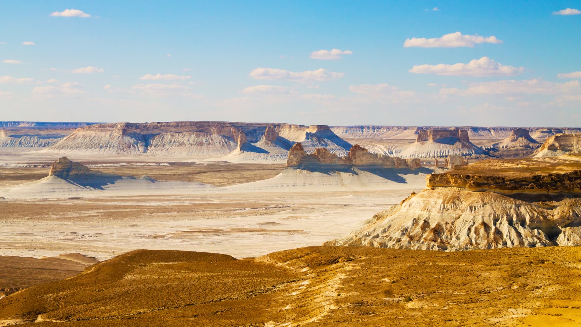
Beyond the city, the territory shifts into the geography of a dried-up seabed. Fifty million years ago, the Tethys Ocean covered the entire area. Its retreat left behind a landscape of chalk plateaus, canyons and isolated pinnacles. Bozjyra, 300 km south-east of Aktau, is its most well-known expression: a closed valley from which calcite teeth 200 metres high emerge, visible from a viewpoint accessible by 4x4 after four hours of track. Tuzbair, further north, is a salt lake bordered by white cliffs that reflect in a thin film of salty water in spring. Further east still, the Kyzylkup canyon exposes red and green strata across several kilometres, and Sherkala mountain, isolated like an inverted yurt, serves as a landmark from the road.
Mangystau is also a land of Sufi pilgrimage. The Beket-Ata sanctuary, carved into the Oglandy cliff, attracts tens of thousands of Kazakhs each year who come to spend the night in the caravanserai before descending to the underground mosque at dawn. Beket Mirzauly, an 18th-century theologian and warrior, is buried here. Eighty kilometres away, Shopan-Ata houses another rock-hewn mosque, older still (10th-12th century). The necropolises scattered across the plateau, Sissem-Ata, Masat-Ata, group together ornamental stelae that mark the lineages of the Adai clans, one of the main tribes of the Kazakh Lesser Horde.
The population remains very sparse: around 700,000 inhabitants for the entire region, concentrated in Aktau and two or three towns (Janaozen, Fort Shevchenko, Beïneou). Between sites, you drive three to five hours without passing a village. The nomadic herders you still meet, especially in spring, tend Bactrian camels, better suited than horses to the scarcity of water. Kymyz (fermented mare's milk) gives way here to shubat, its camel milk equivalent, more acidic. At the table, beshbarmak remains the signature dish, but Caspian fish (pike-perch, sterlet, sometimes farmed sturgeon) features on coastal menus.
The climate is dry and continental, without nuance: less than 150 mm of precipitation per year, summers of 40-45°C where the heat reflected by the chalk becomes uncomfortable from 11 am, windy winters where temperatures drop to -15°C. Water sources are rare and marked on drivers' maps as strategic points. This aridity explains the absence of vegetation cover and the geological clarity of the landscape: the colours of the strata, sulphur yellow, pink, celadon green, are masked by no scrub.
For the traveller, Mangystau is not visited in a leisurely loop. It is crossed by 4x4, in stages of 200 to 400 km of track, with camp under canvas most nights as guesthouses are absent outside Aktau. This is a region we recommend to those who have already seen other deserts (Atacama, Wadi Rum, Gobi) and who are seeking comparable geography without the tourist infrastructure.
To discover
The pinnacles of Bozjyra. Viewpoint 300 km from Aktau, accessible after four hours of track, overlooking a closed valley where calcite teeth 200 metres high rise from an ancient seabed. The oblique light of morning and late afternoon sculpts the volumes.
Night at the Beket-Ata sanctuary. Underground mosque carved into the Oglandy cliff, an active Sufi pilgrimage site. We share the caravanserai here with Kazakh pilgrims who have come to spend the night before dawn prayer.
The Tuzbair salt lake. Salt-rimmed basin bordered by white cliffs, where a thin film of water reflects the walls between March and May. Dry in summer, the salt crust cracks under the tyres.
Sherkala and the Valley of Spheres. Isolated massif shaped like an inverted yurt, neighbour to Torysh, a field of spherical concretions one to three metres in diameter scattered over a few square kilometres.
Bivouac on the Ustyurt Plateau. Three nights under canvas between the Kyzylkup canyons and the Adai necropolises, without network coverage, 100 km from the nearest village. Starlit sky with no light pollution, night-time temperatures 15 to 20°C lower than during the day.
When to visit
We operate Mangystau from April to early June and from mid-September to late October. In April-May, daytime temperatures range between 18 and 28°C, nights remain cool (5 to 10°C in bivouac), and this is the only period when salt lakes still hold water and when the steppes briefly turn green. September-October offer very stable skies, 20 to 27°C during the day, but nights that drop to 3-5°C late in the season.
July and August are to be avoided: temperatures regularly reach 42 to 45°C in the shade, and the reflection off chalk surfaces makes sun exposure difficult beyond a few minutes. Winter (December to February) combines cold (-10 to -20°C), constant winds and tracks sometimes closed by snow or mud. The shoulder seasons in April and October can experience sandstorms lasting 24 to 48 hours that force you to stay at camp.
Practical advice
We recommend five to seven days on the ground, excluding flights, to do justice to the region. Five days allow a short circuit Aktau, Sherkala, Bozjyra, Beket-Ata, return. Seven days add Tuzbair, Kyzylkup and the necropolises of the Ustyurt Plateau, roughly 1,800 km of track spread over the week. Anything less than four days makes little sense: distances between sites range from 150 to 350 km and driving on corrugated tracks tops out at 40-50 km/h.
The entry point is Aktau airport, served by 2.5 hours of flight from Astana or 3 hours from Almaty. The most coherent combination is with Astana and the central steppes, in a west-centre logic, or as an extension of a circuit through Almaty and the Tian Shan for travellers with fifteen days or more. Mangystau sits poorly with the Kazakh Altai (geographical opposite) in a short journey. Comfort is basic: bivouac tents, sometimes basic guesthouse in Janaozen, limited facilities. We orient it towards travellers who are physically self-sufficient, already familiar with desert travel, and not attached to hotel comfort. Families with young children or travellers seeking a sedentary contemplative stay will find more to suit them elsewhere in Kazakhstan.